3DEIA System in Project WATERMAN
Environmental sustainability is critical to the economic development of Hong Kong and the Pearl River Delta; it can only be achieved with the aid of reliable decision support tools. In particular, quantitative impact assessment plays an important role in the sustainable development of our coastal and marine resources. The use of advanced hydro-environmental modelling and visualization technology can help to provide an intuitive and interactive digital platform to better communicate environmental impact assessment (EIA) issues and thus promote continuous public involvement and stakeholder engagement. Such a platform must be based on a robust hydrodynamic model engine that provides seamless predictions from the near to far field, and effective communication and public engagement.
Traditionally, predictions of the environmental impact of various development scenarios (e.g. major bridge crossing, population growth, various degrees of sewage treatment) are mainly presented in the form of two-dimensional hard-copy plans. This type of presentation is not easily understood by non-technical stakeholders; the lack of effective communication tends to breed misunderstanding and mistrust, thus making meaningful dialogue between project proponents and the public stakeholders difficult. With the use of the latest 3D modelling and visualization technology, the public would be able to visualize and better understand the impact of different scenarios and mitigation measures, and offer comments and suggestions in the project planning and implementation stages.
Our objective is to develop a cutting-edge real time GIS based and integrated 3D hydraulic-virtual reality (VR) environmental modelling system (NOVA). The unique technology will enable (i) robust and seamless 3D environmental impact prediction from near to the far field; (ii) full integration with GIS data and advanced visualization capability; (iii) used as an educational tool to introduce concepts such as mixing and transport, and assimilative capacity of the receiving water, and (iv) effective communication and public engagement.
More details about the 3DEIA system in Project WATERMAN are in Here
New land creation by reclamation
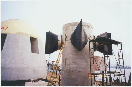
Sewage outfall diffuser cap with duckbill valve
[頁首 Top]
Buoyant jets modeling
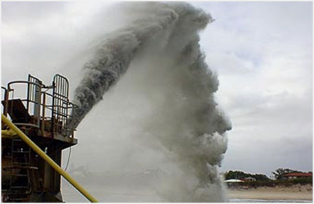
For environmental risk assessment of the environmental discharges, it is necessary to predict the impact of effluent discharges for a wide spectrum of discharge and ambient conditions. The discharged effluent is rapidly mixed with the ambient water in the near field in the form of buoyant jets. The initial mixing ends within several minutes and hundreds of meters from the point of discharge. The effluent is largely diluted (~ 100 times) in the process. Importantly, this phase is under the control of engineers. The mixing of buoyant jets into a stratified co-flowing, cross-flowing, and counter-flowing current, with three-dimensional jet trajectories, has to be modelled.
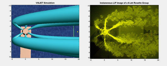
JETLAG/VISJET
is developed as a general computer modelling system that predicts the impact of an effluent discharge into the water environment. The model provides 3D flow visualization of the predicted path and mixing of an arbitrarily inclined buoyant plume in a predicted (3D flow field) or specified ambient conditions. Validated by extensive laboratory and field data,
JETLAG/VISJET
is a robustLagrangian 3D buoyant jet model. It can be used to study the impact of either a single or a group of inclined buoyant jets in three-dimensional space. It can be used for outfall design, impact assessment and risk analysis of polluting or natural environmental discharges (e.g. deep sea hydrothermal vents).
More details are in Here
[頁首 Top]
Near-far field coupling
Mixing in the near field ends when the discharged effluent surfaces or is trapped. The mixed effluent continues to spread laterally due to its remaining buoyancy and forms a thin and wide buoyant spreading. The far field process (secondary dilution due to turbulent dispersion, and bacterial decay) has a time scale of hrs and length scale of km. A typical way of handling the far field is to set up a grid system for the region of interest. Governing equations for the flow and pollutant transport are solved in each of the grid at each of the time step, giving the flow field and pollutant concentration field of the region of interest in every time step by a 3D recirculation model (e.g. EFDC). 3D shallow water circulation models are run on grids in the order of 100 m. Predictions tend to be overly optimistic as the impact is averaged over a region at least of the order of 100 m.
These are important for environmental impact assessment in which the affected region and the pollutant concentration within the region are often needed beyond the near-field. The NOVA system serves as an extension of
VISJET
and it is able to dynamically couple the near and far field of a buoyant jet discharged by a distributed entrainment sink approach (
DESA
).The action of the plume on the surrounding flow is modelled by a distribution of sinks along the plume trajectory and an equivalent diluted source flow at the predicted terminal height of rise. In this way, a two-way dynamic link can be established at grid cell level between the near and far field models. Numerical predictions are in good agreement with basic laboratory data, this include the gavitational spreading from a line diffuser.
DESA
is a major component in the NOVA system of WATERMAN.
More details are in Here
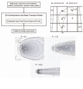
The distributed entrainment sink approach (DESA).
[頁首 Top]
Advanced computer graphics techniques
To be Released Soon
[頁首 Top]
|