Description
NOVA is 3D GIS-integrated software on a local computer for 3D environmental impact assessment (EIA).It provides a powerful tool for quantifying, and hence, the avoidance, minimization and mitigation of different forms of pollution in water bodies. NOVA has the simulation, visualization and data analysis capabilities and is intended to be an EIA tool for professionals and for generating the result files to be used by the internet system.
The most important idea behind the NOVA system is “Integration”. It is produced by integrating knowledge, data and technology. The resulting product is a comprehensive system for water environmental management for Hong Kong. It includes features like submarine outfall design, effluent discharge simulation in near and far field, 3D data visualization and GIS data integration. Hence, it is not just a hydrodynamic and water quality simulator for designing and analysing the marine effluent discharges. Currently, it is configured with Hong Kong’s terrain and water control zones, but it can also be customized to almost any other coastal regions in the world.
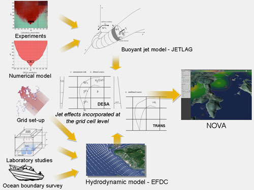
The advanced 3D visualization and internet accessibility of the system would enhance effective communication of water quality and environmental impact. It will also enhance decision making in various accident scenarios in our congested coastal water. Furthermore, the NOVA system is designed with 3D control in mind and fully GIS-integrated to enable instantaneous feedback and data visualization.
Videos
[頁首 Top]
Case Studies
- HATS
Harbour Area Treatment Scheme (HATS) Stage 1 Outfall from the Stonecutters’ Island Sewage Treatment Works without Disinfection
The partially-treated effluent from the Stonecutters Island Sewage Treatment Works is discharged via a 1.1 km long submarine outfall in the western Victoria Harbour. For the present case, the effluent is discharged into the tidal stream through 24 “rosette” risers installed along a diffuser pipe, at a mean depth of around 10 m. Each riser has 8 discharge ports of diameter 0.25 m. In the present example, a total flow of 16 m3/s and bacteria of initial concentration of 2 x 10⁷ counts/100mL are simulated.Other pollution sources in the surrounding area are also included in form of passive source.
In this scenario, the environmental impact (e.g. the elevated E. coli concentration in the Tsuen Wan beaches) from the partially treated sewage of HATS Stage 1 can be assessed.
- Port Shelter
Port Shelter Regional Model and Sai Kung Sewage Treatment Works Outfall – E. coli with secondary treatment
The example simulates the operation of the Sai Kung Sewage Treatment Works (SKSTW) outfall under the design capacity of 22,000 m3/day (0.0141 m3/s per port) in wet season condition. The outfall is assumed to be a 90 m long diffuser with 18 vertical jets of diameter 0.1 m. In this case, the secondary sewage treatment is undertaken and the effluent E. coli concentration is reduced to 1500 counts / 100mL. Pollution loads from 12 storm outfalls is also included.
The regional flow model uses a 153 x 153 x 8 curvilinear grid and has 12524 active cells. The tidal forcing at the open boundary consists of the nine tidal constituents (O1, P1, K1, N2, M2, S2, K2, M4, and MS4) and the flow field for 4 days is pre-simulated. The wet season condition is considered, a linearly varying salinity is assumed at the upper half of the water column (layer 1 (surface), 33 ppt; layer 2, 33.5 ppt; layer 3, 34 ppt; layer 4, 34.5 ppt) and constant at the lower half (layer 5-8, 35 ppt) are specified at the open boundaries.
In this scenario, the environmental impact (e.g. the salinity changes in the ambient water) from the secondarily treated sewage of SKSTW can be assessed.
- Pillar Point sewage pipe damage incident
At around 3~4 am on the early morning of 8 July in 1997, a dredger damaged a submarine sewage pipe where was about 30 m away from the shore. The sewage was from Pillar Point Sewage Treatment Works at which the sewage only received preliminarily screening treatment. At about 11 am~12 noon on the same day, it was found that the E. coli levels in the nearby TuenMun beaches exceeded Water Quality Objectives (WQO) by 16 times in the regular water quality sampling conducted by Environmental Protection Department (EPD). In particular, the E. coli level at Kadoorie was up to 15000 counts/100 mL. On 11 July, five TuenMun beaches were closed due to the excessive E. coli levels
In this scenario, the E. coli level in this area of interest is simulated with/without the sewage pipe damage. Through the visualization of NOVA, the reason of the increased E. coli levels at the beaches can be explored and the relevant risk management can be achieved.
[頁首 Top]
|