Introduction | Our Team | Collaborations | Steering Committee | Main Page
The Hong Kong Water Environment
Environmental sustainability is critical to the social and economic
development of the Hong Kong Special Administrative Region (HKSAR) in the coming
decade. All indications suggest that our "World City" will become a Mega City of
some eight million population, a tourist attraction for the hinterland, the
region and beyond, and an increasingly knowledge-based service economy. The
water management, social well-being and international image of our city can
benefit greatly from an innovative internet and GIS-based environmental
knowledge base.
The HKSAR has a total land area of around 1,100 square kilometers (km2) and a
total coastal water area of around 1,800 km2. The coastal marine waters of Hong
Kong are heavily used for a number of activities that support the economy and
well-being of Hong Kong: navigation, recreation, fisheries, waste disposal,
industrial water supply, dredging for fill material, and environmental
conservation and scientific work. At present, the management of the precious and
intensively utilized coastal waters is based on past data derived from a
comprehensive water quality-monitoring network (of 56 stations) that was
established some 20 years ago. The water quality is sampled once
monthly/bimonthly at these stations to detect trends in water quality and
provide management data.
Objectives
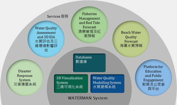
We propose to develop an innovative environmental knowledge base, named
WATERMAN, for all of Hong Kong's waters. There are four major components: (1)
Beach water quality forecast system; (2) Fisheries management system; (3) 3D
Environmental Impact Assessment system; and (4) Educational platform. The system
aims at providing: (i) daily beach water quality forecasts and advisories; (ii)
on-line water quality and flow information for key coastal sites; (iii) data on
carrying capacity and flushing rate of fish culture zones; (iv) short-term
prognosis for red tide outbreaks and water pollution disasters; (v) virtual
reality water quality assessment for environmental impact assessment, monitoring
and audit of infrastructure projects such as wastewater treatment and
desalination plants.
Benefits
The environmental management of Hong Kong can benefit greatly from our new
internet and GIS-based water quality forecast, management and 3D visualization
system. The proposed system will be developed with an integrated IT platform
that allows relevant water quality data to be communicated to the public over
the internet: e.g. daily beach water quality forecasts, information for
fisheries management, pollution disaster response. It will also enable 3D water
quality assessment for public engagement in a number of commonly encountered
settings. The overall objective is to provide the general public with the means
to better understand the quality of water around them and to allow them to
engage in a meaningful discussion of events that may impact the water
environment (natural or man-made e.g. rainstorms). The system will enhance
public awareness of water-environment; it will also facilitate the sustainable
development of Hong Kong. The beneficiaries are expected to include government
decision makers (EPD, DSD, AFCD, LCSD), engineers and consultants who are
involved in infrastructure projects, fishermen, and the general public who has a
right to be informed about our marine environment for enjoyment and
conservation.
This project is a joint venture of the Croucher Laboratory of Environmental
Hydraulics and the Department of Computer Science of the University of Hong
Kong. WATERMAN is an offspring of two decades of competitive externally-funded
cutting-edge research (RGC/Croucher/ITF/UGC) carried out by the Principal
Investigators on environmental hydraulics and visualization technology.