|
Example 2: Minimization
Harbour Area Treatment Scheme (HATS)
Harbour Area Treatment Scheme (HATS) represents a major environmental infrastructure in Hong Kongthat collects the sewage from the densely populated urban areas on both sides of VictoriaHarbourtoa centralized sewage treatment works at Stonecutters Island (SCISTW). Based on the EIA studies on four siting options, the centralized sewage submarine outfall at Stonecutters Island can best minimize the environmental impacts induced by sewage and sludge discharge on both sides of the harbour.
There are two stages of HATS:Stage 1 is designed to collect the preliminarily treated sewage in Kowloon for furthertreatment at SCISTW. Since the commissioning of Stage 1 in December 2001, an overall improvement of harbour water quality is observed: an average increase of dissolved oxygen by about 10%; an average reduction of ammonia by about 25%; an average reduction of E. coli by about 50%.
Whilst the remarkable improvement of overall water quality in the harbour, the western harbour (especially the area of Tsuen Wan beaches) is affected by the large volume (1.4 million m3/d) of chemically enhanced primary treated (CEPT) sewage discharged from the SCISTW. Seven beaches in Tsuen Wan district have been closed due to excessive E. coli level since 2003.After the implementation of Stage 2A in 2014 which collects the remaining untreated sewage fromHong Kong Island, the discharged sewage isapproximately2.4 million m3/d.To minimize the environmental impacts induced by such a large volume of partially treated sewage, disinfection units with chlorination have been in operation since March 2010. It is noticeable that the water quality in Tsuen Wan beaches is improved and meets the water quality objectives. Four beaches (Lido, Casam, Approach and Hoi Mei Wan) are decided to re-open on 15 June 2011.
In Stage 2B, the sewage treatment level is upgraded to secondary biological treatment to further reduce organic matter for minimization of environmental impacts.
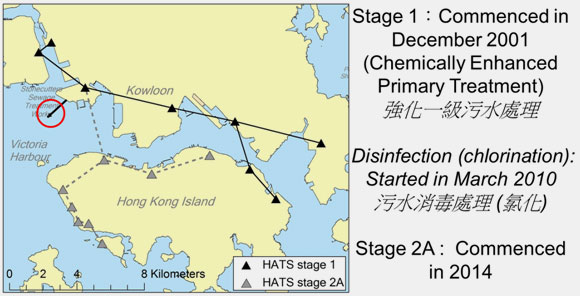
Figure 6.Harbour Area Treatment Scheme (HATS).
Example 3: Mitigation
Optimization of disinfection (chlorine) dosage of HATS
Worldwide, there are three common disinfection approaches: chlorination, ozonation, and ultraviolet (UV). Among the three, chlorination is the most cost-effective with low capital and operation cost. By oxidation of cellular material, chlorination can reduce the levels of a wide range of microorganisms by 99%. Advantages of this well-developed disinfection technique also include the relatively high reliability and low maintenance.
Despite of the effectiveness of chlorination, there are some environmental impacted from chlorination. Chlorine residuals, even at a low concentration, is highly toxic to fish and other aquatic life. During the chlorination process, hazardous compounds (e.g., trihalomethanes“THMs”) are formed. These chlorination byproductsare carcinogenic to humans.Hence, optimization of chlorine dosage becomes a crucial topic to mitigate the environmental impacts induced by the disinfection (chlorine) operation.
|